


In partnership with The Navigator Company, Floradata carried out an inventory in April 2023 in Southwest Alentejo and in the Monchique mountain range. To confirm the data previously collected, but also mindful of the possible occurrence of new faunal and floristic species under threat, new concrete measures for their preservation will be put in place based on the conclusions of this inventory.
Imprima ou partilhe nas suas redes sociais:
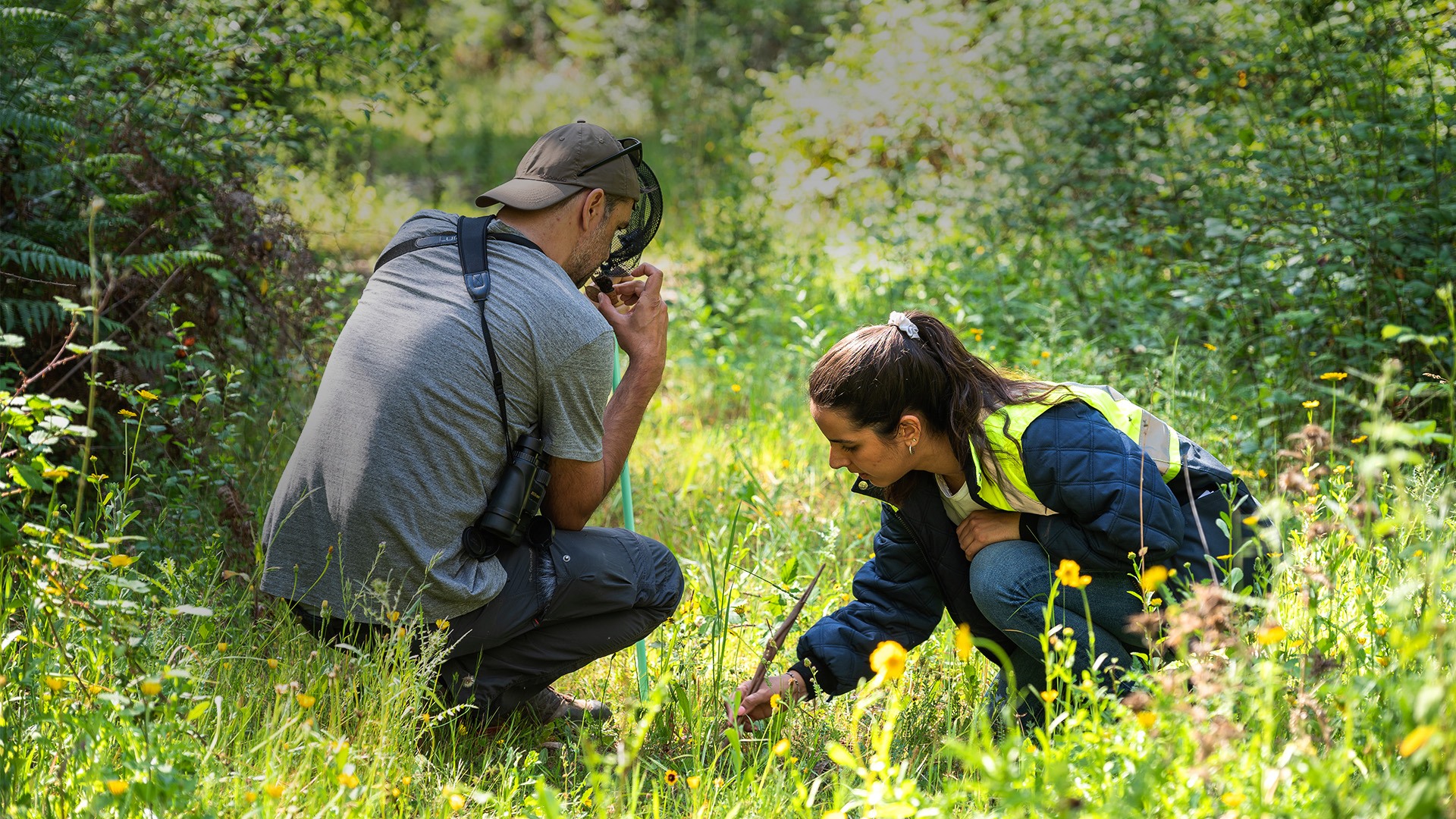
Inventorying the natural values that occur in properties managed by The Navigator Company, especially those included in classified areas (such as the Natura 2000 Network) or in protected and conservation areas, means collecting up-to-date data about the company’s natural heritage. “Our sampling is virtually a photograph of a place at a given time,” explains Duarte Mendes, a Floradata biologist and fauna specialist involved in this inventory operation.
After identifying the fauna and flora species and also the habitats found, this information is entered in the Navigator database and becomes a fundamental tool to assess the conservation status of biodiversity in the designated area, in that particular period. This is exactly what was done in this most recent inventory conducted in the Southwest Alentejo and in the Monchique mountain range.
This fieldwork focused on the “characterization and cartography of the existing natural habitats in these areas, but also on the various species of flora and fauna that we can find”, the scientific director of Floradata, Paulo Alves, told Biodiversidade.com.pt. The time of year was not chosen at random: given our knowledge of the area to be inventoried, we had to optimize the visit and choose the “right time, when biodiversity is at its peak so that we might have more opportunities to find several species”, he explains.
The resulting changes in the preservation and conservation measures after this inventory cannot be restrictive, he added: “Sometimes it is not worth restricting the movement of people, restricting grazing, as it can even be beneficial. It is important to remember that protected species can live side by side with people. ”

The methodologies of the inventory process
To inventory fauna and flora, different methodologies are used with a first phase in common – that of preparation –, checking forms and cartography, preparing GPS and maps and predicting, given the existing type of habitats and the characteristics of these areas, what species might be there. Transects are also stipulated, that is, sections and strips of land in which the species that occur are recorded and accounted for.
On the ground, each group requires a different identification methodology:
Birds
In addition to the direct observation of birds, listening points are created and, with the help of binoculars, species are identified. Sometimes, when observing other species, unidentified birds come up and are added to the list.
Reptiles and amphibians
In the herpetofauna group (reptiles and amphibians), identification is done through active prospecting, that is, looking for them in their traditional shelters, under trunks or, identifying amphibians, near the waterways, where they breed.
Mammals
In each transect, we look for evidence of the presence of these animals, such as footprints, burrows or manure. This is the most difficult group to inventory given the mobility of these species.
Flora
But to make an inventory of the existing plant species we have to be on the ground. Photography is also used as a means of documentation and phytosociological inventories are also made to help us understand a plant community or a habitat. Capturing diversity, Paulo Alves states, is the biggest challenge in this group: “During springtime, this area has hundreds of species in one place and we need to find the rarest and also list the most common”.
Habitat
Habitats under the Habitat directive are part of a list of biotopes selected by the European Union and contained in Appendix 1. Biotopes, as Paulo Alves explains, are “places with a particular homogeneous vegetation or geology: a river of a certain size that never dries is a biotope; a riverside forest is also a habitat in its broadest sense”. Identifying habitats therefore requires considering all elements of the area under analysis. “Riparian groves, next to the river, the willows in our path, cork oak forests, oak trees (Portuguese oak and Monchique oak), one of the rarest habitats at the moment, arbutus groves, characteristic of the Monchique mountain range and which are part of the economy itself with several obtained from arbutus”, all of these are habitats.
After the inventory, we need to review the cartography and description of the species, namely the common names, type of habitat and the legal protection that is there to ensure their conservation.

Further objectives of the inventory in the Monchique mountain range
A further purpose of this inventory is the possible creation of High Conservation Value Areas insider Navigator properties. These areas are critical for conservation, given the importance of their assets and are the object of specific measures to preserve flora and habitats, but also fauna (for example, Bonelli’s eagle nesting sites). “We are talking very important areas, such as the Monchique oak trees , a vulnerable and very rare species, or the alder forests, such as the adelph,” Paulo Alves explains.
And regarding the oak tree, Inês Fontes, an expert in the prevention of The Navigator Company areas working on the ground , adds that, in that area, “our most protected species are precisely the Monchique oak tree , which only exists here and which has been studied a lot by our team. In the future, we would like to have more data to understand if we are progressing in the right direction”.
In addition to this expectation, there is another: to be able to list the variety of biodiversity that exists in the vicinity of forest production areas, improving the management measures in force. Duarte Mendes says that “what is most surprising is that these recovery areas promoted by Navigator have had a very interesting diversity associated with them, much richer than what we would normally associate with a forest production area”. This biologist hopes to find in the Monchique mountain range the “Bonelli’s eagle , a very rare prey that is classified “Endangered” in Portugal, and that we know exists in this area” and others such as the otter and amphibians such as the pointed snout frog.
This inventory enables us to understand also that some species that were considered new and rare in Portugal are not – see for example the species of the genus Carex that, in the several inventories conducted in Navigator properties, proved to be more common than we thought, “especially in the pathways with some humidity”, a clear sign that, as there were not many experts, it was not properly studied, Paulo Alves points out.
Inês Fontes says that it is “always rewarding to find new species and new habitats that we do not yet have in our data and to be able to translate the results into management measures”. In this subsequent management plan, specific preservation measures will be considered for this property, with the identified species of fauna and flora in mind.
Inventorying to manage effectively
To know the forest in-depth, inventorying and monitoring it is essential for effective land management. From the conclusions of each inventory, information is extracted that will then lead to the necessary adjustments, in the field, and for the planning and execution of activities that may result, at least, in upholding the values of biodiversity and the existing ecosystem services in the heritage (or in the net loss). In addition to allowing a systematic comparison, these data are also a source of useful information on several fronts, not only as regards compatibility with forestry operations but also in the process of requalification or renovation to obtain a net positive gain.
But modern inventory is not only based on on-site observation and now relies on other means. We speak, for example, of drones with satellites equipped with LiDAR (Light Detection and Ranging) sensors – such as those one used in the mapping and georeferencing of Quinta de São Francisco – which characterize the forest area with greater accuracy, providing data such as the height, width and volume of the vegetation, providing a 3D model of the terrain with an accuracy not yet achieved by other means. In this case, as in so many others, information is power, allowing effective management, and adapted to the fauna and floristic characteristics of forests.
